Benchmark
pyarchinit-photogrammetry, Agisoft Metashape Pro and ODM (the engine of WebODM) on the same photos of a tell, on the same computer, with the same resolutions: the time of every step and the quality of the results.
How
- Computer: Apple M4 Pro (8 performance and 4 efficiency cores), 24 GB, macOS 27. Metashape uses the GPU (Metal) as well as the CPU; pyarchinit-photogrammetry and ODM use the CPU only: pyarchinit-photogrammetry natively, with its native core, ODM in Docker (a Linux virtual machine with 11 cores and 8 GB).
- Data: Tell Sultan (Syria), a DJI drone with an FC8482 camera (4032 × 2268 pixels): the 57 photos of the tutorial (about 110 m above the ground, 3.6 cm per pixel) and the whole survey of 425 photos (nadir flights at about 40, 65 and 110 m, and oblique photos).
- Settings: features found on the photos at half size (Metashape Medium accuracy, ppg High,
ODM
--feature-quality high), depth maps at a quarter (Metashape Medium, ppg Medium, ODM--pc-quality medium), moderate filtering, DEM from the dense cloud, orthophoto on the DEM, mosaic blending; ODM's DEM and orthophoto at the resolutions Metashape chose. Georeferencing by the GPS of the drone: no ground control on Tell Sultan. - Quality: the products of each program are brought onto those of Metashape - a shift found by phase correlation of the hillshades, then refined together with an offset, a tilt and a height scale by least squares surface matching: each program places a survey known only from the drone GPS a little differently - and compared: NMAD and 95th percentile of the height differences, the ground covered, the sharpness of the orthophotos where all of them cover it. The reprojection error is the RMS over all the observations of the tie points, in pixels of the photos.
The scripts are in the repository (benchmark/): run them on your data and computer.
GPU and CPU
On a Mac, Metashape runs its heaviest steps - the matching of the photos and the depth maps - on the GPU through Metal, besides the CPU; pyarchinit-photogrammetry and ODM run everything on the CPU. The times compare the programs as they run on this computer, not the algorithms on the same hardware. Version 1.2 of pyarchinit-photogrammetry uses the GPU as well: see With the GPU below.
57 photos (the tutorial)
Times in seconds:
| Step | pyarchinit-photogrammetry 1.1 (CPU) | Metashape Pro 2.1.3 (GPU + CPU) | ODM 3.6.2 (CPU) |
|---|---|---|---|
| Alignment | 190 | 18 | 119 |
| Depth maps and dense cloud | 158 | 79 | 170 |
| Mesh | 32 | 32 | 51 ¹ |
| Texture | 8 ⁶ | 19 | 54 |
| DEM | 8 | 4 | 3 |
| Orthophoto | 20 | 26 | 7 |
| Total | 416 | 179 | 418 ² |
Results:
| pyarchinit-photogrammetry | Metashape | ODM | |
|---|---|---|---|
| Photos aligned | 57 / 57 | 57 / 57 | 57 / 57 |
| Tie points | 316,000 | 65,000 | 55,000 |
| Reprojection error (RMS) | 0.97 px | 1.05 px | - |
| Dense cloud | 3.1 M points | 4.2 M | 6.1 M |
| DEM | 19 cm | 15 cm | 15 cm |
| DEM against Metashape's: NMAD / 95th percentile | 14.4 / 52 cm | - | 14.2 / 75 cm |
| Ground covered by the DEM ³ | 95 % | 100 % | 99 % |
| Orthophoto | 3.6 cm | 3.8 cm | 3.8 cm |
| Orthophoto sharpness ⁴ | 58.3 | 52.8 | 35.0 |
| Ground covered by the orthophoto ⁵ | 64 % | 79 % | 90 % |
¹ the 2.5D mesh ran out of memory once and was made again with fewer processes. ² with the georeferencing and the report. ³ cells of the common grid with a height, Metashape's DEM = 100 %. ⁴ variance of the Laplacian of the grey image at 2 cm, median of the tiles covered by all of them. ⁵ share of tiles of the common footprint; ODM fills to the edges of the flight. ⁶ without the colour correction of the photos, as Metashape without its colour calibration (with it, as in the window: 27 s).
Notes:
- Metashape matches and aligns on the GPU: 18 s, against 119 s for ODM and 190 s for ppg on the CPU.
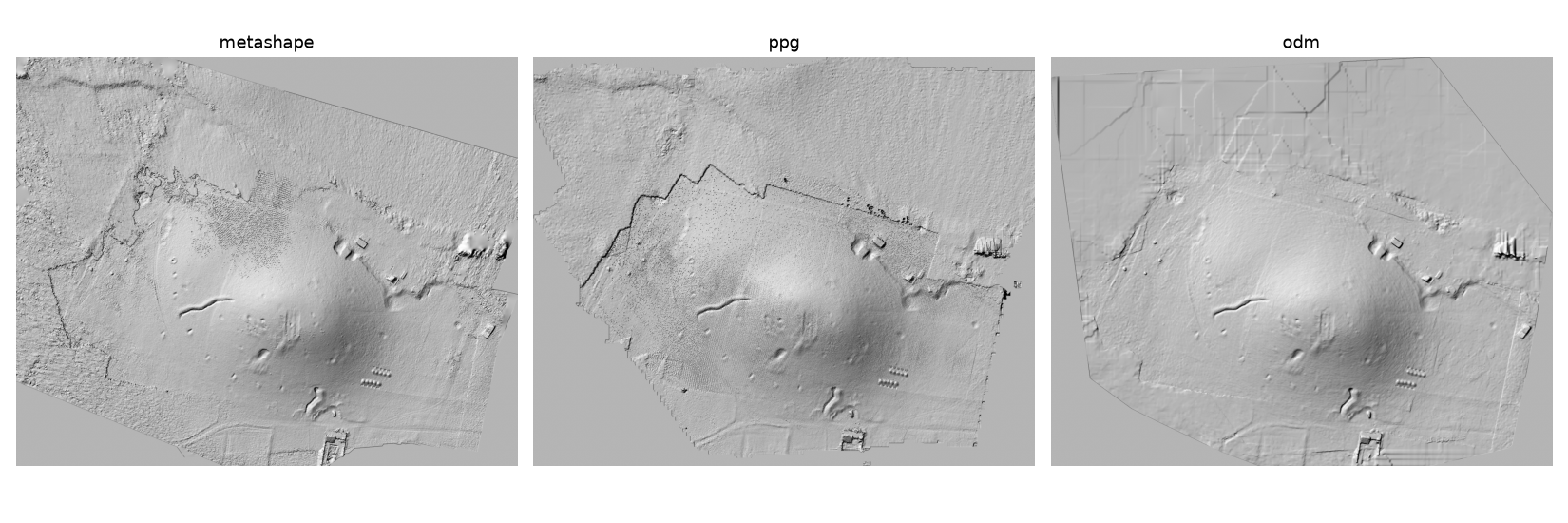
- ppg computes the depth maps of a survey from the air with PatchMatch in its native core: no contour-like terraces and stripes, which two-view stereo drew on this tell.
- ODM's orthophoto is the softest: it is draped on a 2.5D mesh simplified to 400,000 faces; its DSM fills the gaps with straight-sided patches (visible in the north).
- The line across the north-west of ppg's hillshade is the edge of the ground seen by three or more photos: beyond it, where two photos see the ground, the surface of ppg sits about 20 cm higher. The dense cloud of ppg keeps the points seen by at least three photos, and every plane of its depth maps needs two photos seeing it (before this benchmark that margin was pitted by a few wrong points).
- A block flown at one height and placed by the GPS of the drone alone does not fix the scale of its own heights: against Metashape's DEM of the whole survey (425 photos, three heights), the heights of the 57-photo surveys of both programs are stretched by about 3 % (a height scale of 0.97 brings them back, with a residual dome of 23 cm NMAD for Metashape and 34 cm for ppg). The comparison above, between the products of the same 57 photos, does not see it.
- ppg's orthophoto is the sharpest: for every spot it takes the photo that sees it at the highest resolution.
425 photos (the whole survey)
Times in seconds:
| Step | pyarchinit-photogrammetry 1.1 (CPU) | Metashape Pro 2.1.3 (GPU + CPU) | ODM 3.6.2 (CPU) |
|---|---|---|---|
| Alignment | 1,775 | 205 | 903 |
| Depth maps and dense cloud | 1,111 | 872 | ⁷ |
| Mesh | 216 | 278 | |
| Texture | 122 | 131 | |
| DEM | 71 | 16 | |
| Orthophoto | 112 | 146 | |
| Total | 3,407 (57 min) | 1,648 (27 min) | did not finish ⁷ |
⁷ in its virtual machine of 8 GB ODM ran out of memory while fusing the depth maps of the 425 photos, by tiles too, and stopped without a dense cloud.
Results:
| pyarchinit-photogrammetry | Metashape | |
|---|---|---|
| Photos aligned | 425 / 425 | 425 / 425 |
| Pairs of photos matched | 6,060 | - |
| Tie points | 1,985,000 | 556,000 |
| Reprojection error (RMS) | 1.22 px | 1.34 px |
| Dense cloud | 22.2 M points | 15.5 M |
| Mesh | 1.48 M faces | 1.24 M |
| DEM | 7.1 cm | 8.2 cm |
| DEM against Metashape's: NMAD / 95th percentile | 12.0 / 39 cm | - |
| Ground covered by the DEM ³ | 98 % | 100 % |
| Orthophoto | 2.0 cm | 2.0 cm |
| Orthophoto sharpness ⁴ | 636 | 347 |
Notes:
- The alignment is where ppg is far behind: 6,060 pairs of photos matched on the CPU with 40,000 points per photo, then all the cameras placed at once; Metashape matches on the GPU. After the alignment the two are close: 1,632 s for ppg, 1,443 s for Metashape.
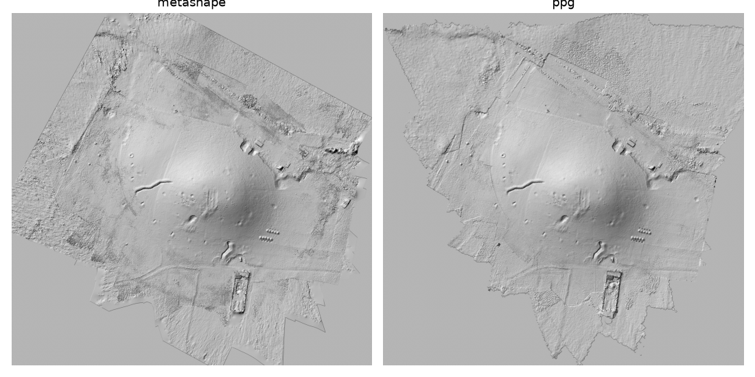
- ppg's dense cloud keeps the points seen by at least three photos: at the margins of the flights it is sparse and the DEM is interpolated there (smoother than Metashape's), while it is far denser where dozens of photos overlap (the low flights over the centre).
- Once each survey is placed on the other, the two DEMs agree within 12 cm (NMAD). The broader differences - a ring 15-25 cm lower than Metashape around the centre of the tell, the borders higher - are a difference of self-calibration: ppg refines two radial coefficients with the principal point fixed, Metashape three radial and two tangential coefficients and the principal point; placed by the GPS of the drone alone, neither survey can be called right. The depth maps are not the cause: computed from Metashape's alignment, ppg's agree with Metashape's tie points within 2 cm per photo. The benchmark on Tell Tuqan below, with ground control points, measures the absolute accuracy of both programs.
997 photos with ground control (Tell Tuqan)
Tell Tuqan (Syria), the flight of the targets: 997 photos of 8064 × 4536 pixels (48 Mpx, DJI FC8482) and 11 coded targets measured on the ground - 7 control points, 4 check points, 2 cm horizontal and 3 cm vertical accuracy - with the same marker projections (measured in Metashape by the surveyor) given to both programs. Settings as above scaled to the 48 Mpx photos: features on the photos at a quarter (2016 px: Metashape Low, ppg Medium), depth maps at an eighth (1008 px), moderate filtering, mesh with a medium face count, texture 4096, DEM from the dense cloud, orthophoto on the DEM. ODM was not run (see the 425 photos).
Times in seconds:
| Step | pyarchinit-photogrammetry 1.1 (CPU) | Metashape Pro 2.1.3 (GPU + CPU) |
|---|---|---|
| Matching | 3,391 | 972 |
| Alignment | 23,110 ⁸ | 455 |
| Optimization on the control points | 2,231 | 25 |
| Depth maps and dense cloud | 2,884 | 4,218 |
| Mesh | 244 | 2,579 |
| Texture | 3,076 | 2,621 |
| DEM | 166 | 85 |
| Orthophoto | 10,903 ⁹ | 2,401 |
| Total | 46,007 (12 h 47 min) | 13,355 (3 h 43 min) |
⁸ incremental alignment: the global one, used for the 425 photos, bent this ring (see the notes). ⁹ three hours of which the disk, not the program, set the pace (see the notes).
Results:
| pyarchinit-photogrammetry | Metashape | |
|---|---|---|
| Photos aligned | 988 / 997 | 995 / 997 |
| Tie points | 4,681,000 | 1,244,000 |
| Control points: RMSE (horizontal / vertical) | 2.7 cm (0.3 / 2.7) | 2.7 cm (2.3 / 1.6) |
| Check points: RMSE (horizontal / vertical) | 66.3 cm (51.4 / 42.0) | 28.6 cm (13.4 / 25.2) |
| Dense cloud | 37.6 M points | 78.7 M points |
| Mesh | 2.51 M faces | 4.61 M faces |
| DEM | 5.5 cm | 4.1 cm |
| DEM against Metashape's: NMAD / 95th percentile ¹⁰ | 50 cm / 1.36 m | - |
| Ground covered by the DEM ³ | 91 % | 100 % |
| Orthophoto | 8.0 mm | 5.1 mm |
| Orthophoto sharpness ⁴ | 915 | 780 |
¹⁰ compared as they are, without the registration used on Tell Sultan: both surveys stand on the same control points.
Notes:
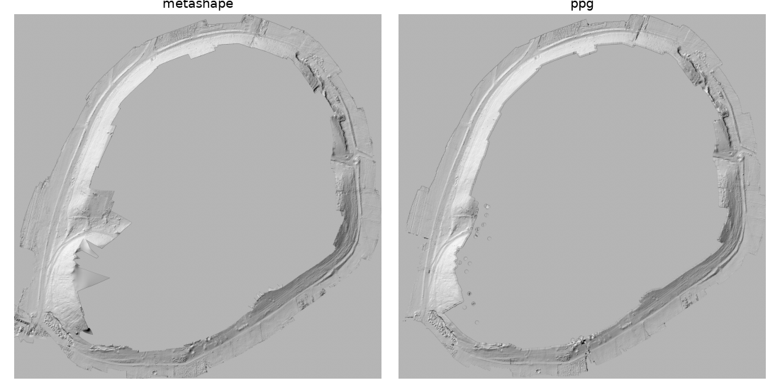
- The flight of the targets is a closed ring around the tell, some 650 m across, flown once with the camera on the targets and without RTK (the GPS of the photos is accurate to 5 m horizontally and 10 m vertically). What both programs reconstruct is the strip of ground under the ring: the tell in the middle is not covered, as the hillshades show.
- The alignment is the whole story of this survey. ppg's global SfM, which did well on the 425 photos, placed every photo of the ring but bent it: consistent locally (the targets re-projected within 1-3 pixels) while the scale changed from one side of the ring to the other, and the targets ended up some 90 m from their coordinates. The incremental mapper got the ring right at the cost of 6.4 hours, and its block was still bent by a few metres before the control points (2.6 m RMSE on the control targets, a group of 25 photos 14 m off): a free ring of a thousand oblique photos, without strips across it, drifts. Metashape uses the GPS of the photos within its alignment and does not. Adding the GPS of the photos to ppg's bundle adjustment afterwards only brought the control error from 2.6 to 1.8 m: the tie points hold the bend.
- The optimization on the control points had to reach targets metres away from the block: the targets are taken as fixed points in steps, on a subset of the strongest tracks, then the whole block is re-triangulated and adjusted (37 min). It brings the control points to 2.7 cm, as Metashape, but the check points to 66 cm against Metashape's 29 cm: three of the four check targets stay 25 cm to 1.3 m off (the fourth 2 cm), the worst in the group of 25 photos that remains a metre from Metashape's cameras.
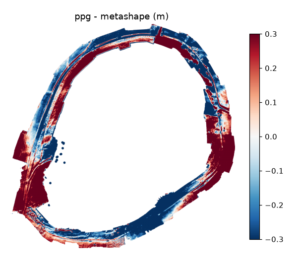
- The two DEMs, compared as they are, differ by 50 cm (NMAD): not noise, but waves of ±0.3-1 m along the ring in the difference map - the residual bend of ppg's block - with agreement where the ring passes the control targets. The ten RTK points measured on the ground fall outside the strip: ppg's DEM has no cell at any of them (3 to 80 m from the nearest), Metashape's reaches three, two within 0.6 m and one 2 m off in a patch it interpolated across a gap (the spikes in its hillshade).
- After the alignment, ppg's depth maps, dense cloud, mesh, texture and DEM take 6,370 s on the CPU against Metashape's 9,503 s with the GPU, and its orthophoto is the sharper one. The orthophoto time is not the program's: the 28 GB of 48-megapixel photos do not fit in the 24 GB of the Mac, ppg re-reads them for every tile, and the external SSD they sit on was shared with other work for most of those three hours (alone, the last stretch ran five times faster). A photo cache sized on the memory rather than on the workers is the fix to make.
- ODM was not run (see the 425 photos).
With the GPU (version 1.2)
Since version 1.2 pyarchinit-photogrammetry runs two of its heaviest steps on any GPU through wgpu (Metal on the Mac, Vulkan and DirectX 12 elsewhere) together with the CPU: the matching of the SIFT descriptors and the PatchMatch depth maps. Measured on the same computer and photos as above (the GPU of the M4 Pro is the integrated one), the whole matching step - the features, the preselection of the pairs and the matching itself - in seconds:
| Photos | CPU only (1.1) | GPU + CPU (1.2) |
|---|---|---|
| 57 (689 pairs, about 50,000 descriptors per photo) | 104 | 98 |
| 425 (6,065 pairs) | 1,103 | 957 |
On this Mac the integrated GPU takes a quarter of the pairs: its kernel matches a pair of 50,000 × 50,000 descriptors in 318 ms (2 TFLOP/s), COLMAP's matcher on the 12 cores in 131 ms including the geometric verification, so the two together can be at best 29 % faster than the CPU alone (the matching itself went from 75 to 67 s on the 57 photos); on a computer with a discrete GPU the ratio turns around. The depth maps gain more: on the synthetic test scene 26 PatchMatch depth maps take 1.9 s on the GPU against 12.2 s on the CPU, with the same heights within a tenth of a millimetre.
After 1.2.2 two more steps moved to the GPU (in the next release), with the same results as COLMAP's code: the SIFT key points - the photos read and reduced exactly as COLMAP reads them, so the GPU finds 99 % of the points of COLMAP's extractor with the same descriptors - and the fusion of the depth maps into the dense cloud, one thread per pixel checked against the maps covisible with it, with the confidence of every point counted in the same pass. On the 57 photos the key points take 11 s against 19 s on the 12 cores (0.19 s per photo on the GPU, 3.2 s on one core), the fusion 1.8 s against 4.5 s of COLMAP's fusion and the confidence; the fused cloud no longer absorbs the pixels around a point, so it is as dense as the depth maps (on the synthetic scene 2.7 times the points, the 90th percentile of the height errors 2.4 mm against 3.0, the DEM 3.5 mm against 5.7). The run of Tell Tuqan with every GPU part in place is in progress.
What changed in pyarchinit-photogrammetry
These tests changed the program; the numbers above are those of the version with the changes:
- alignment of many photos: the pairs that overlap found first on photos reduced to 1024 pixels, the 20 strongest of each photo matched in full, all the cameras placed at once (global SfM): 57 photos 472 → 177 s, 425 photos 42 → 27 min, the same cameras within 1 cm (RMS);
- depth maps of surveys from the air with PatchMatch, every plane confirmed by two photos, and a fusion that keeps the density of the depth maps: 57 photos 1.1 → 3.1 M points, no contour-like terraces;
- DEM: resolution from the ground the cloud covers; spikes, stray points and the pits of a few wrong points removed; the sparse margins interpolated as one surface instead of scattered dots: 425 photos, 45 → 64 % of the common ground, 95th percentile of the differences 87 → 39 cm;
- optimization on control points that lie metres from the block: the targets are reached in steps (continuation) on the strongest tracks, then the whole block is re-triangulated and adjusted; a single adjustment from that far diverged (Tell Tuqan: control targets from 2.6 m to 2.7 cm).